Some regions (`holes') were removed from the survey
area to avoid saturated stars, satellite trails and other plate or
scanning defects. Definition of these holes is probably the most complicated
part of all the data on this page. Please read all the following carefully before
trying to use the hole files.
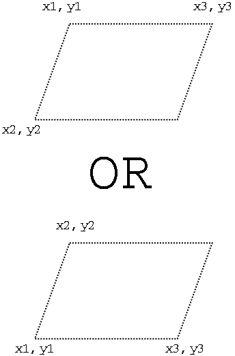
Holes were specified by giving three corners
coordinates with the fourth being calculated, since all holes
are parallelograms. For the three positions given, point 1 is always the
included corner between points 2 and 3. The orientation of the hole is
however variable. That might be more easily explained by
a figure.
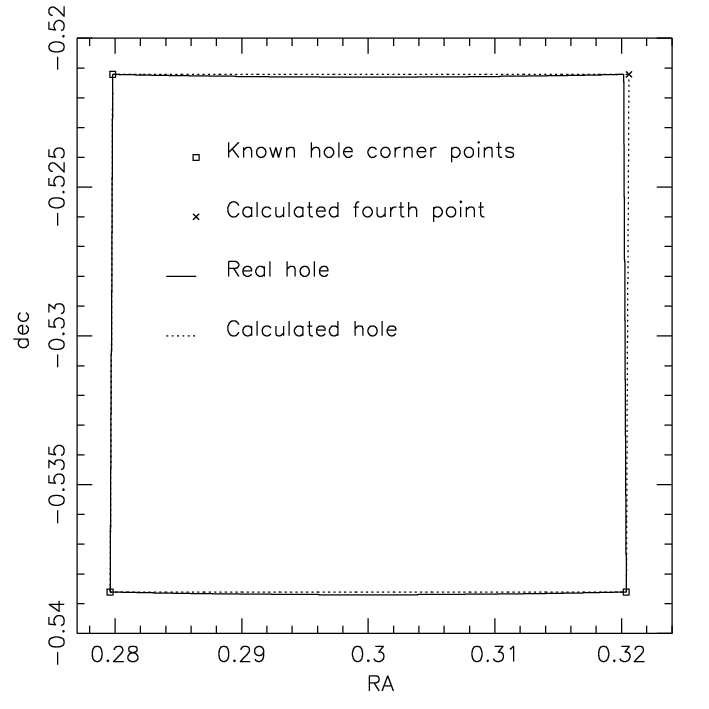
Using these data at their highest accuracy is awkward because
holes were defined in scan pixel coordinates before the astrometry was
performed, so holes are not exactly `square' in RA,dec due to the transformation into a spherical
coordinates and plate distortions. This is illustrated by
this figure,
which shows a rectangular 2°×1° hole in the SGP.
Two distortions occur. First, the sides are not straight lines in RA,dec and
second, the fourth corner no longer defines a parallelogram, so calculating its position
from the other three is no longer possible. To circumvent the second problem, we
publish all four corners when giving holes in RA,dec as opposed to three points in scan coordinates. This does
nothing to correct the issue of non-straight sides.
The error is very small in most cases, but
depending on application, could become significant (10 arcsec, see below) for very large holes.
For the highest precision, a position must be converted from RA,dec into
APM scan coordinates in order to be test against the definitive scan
coordinate holes. For conversion between scan coordinates and RA,dec, see the
astrometry section above. We would not anticipate this
really being necessary for many users of the catalogue, but make the facility
available.
The data are available in three formats. The third data set below is that
most likely to be useful in the widest range of circumstances.
- In scan coordinates. Three corners are specified as X,Y pairs. X corresponds closely,
though not exactly, to RA. Point one is connected directly to both points 2 and 3.
The fourth point is calculable (see explanitary figure).
For perfectly rectangular or square holes, X1 = X3.
The final column specifies the plate to which the hole applies. Where a hole extends beyond the edge
of the plate, it does not go on to the adjacent plate. You must check which plate a location
is on before checking against holes for that plate.
Equatorial X,Y holes,
SGP X,Y holes.
- All holes in RA,dec (J2000, in radians). Four corners are given. The holes are now
only very approximately parallelograms. Points 1, 2 and 3 refer to the same points
in the scan coordinates X,Y hole files. These holes are those shown with
dotted lines in the pictures of the holes. (
PS picture of Equatorial holes.
PS picture of SGP holes.)
The final three columns in the data files are a simple sequential flag
identifying the plate (1-15), a hole number on that plate (1 to N) and the plate/field name.
The hole and plate numbers are the same as those on the pictures referenced above.
As with X,Y holes, were a hole extends beyond the edge
of the plate, it does not go on to the adjacent plate.
If using the full 3 million object UBR catalogue, you will need these holes rather than the truncated ones
below.
All equatorial RA,dec holes,
All SGP RA,dec holes.
- 2QZ Holes in RA,dec (J2000, radians) truncated so as not to overlap plate edges. These holes
are shown in the pictures (
PS picture of Equatorial holes,
PS picture of SGP holes)
as solid lines. They are specified as four cornered irregular polygons. Where
a triangular hole is required, corners 3 and 4 are identical. Data format
is identical to the above RA,dec holes, but there are fewer lines because many
holes fall outside the survey regions used. Hole label numbers are kept consistent
between the data sets. The corners are correct (i.e.,
correspond to the definitive X,Y scan coordinate holes) to better than 0.1 arcsec.
In the most extreme case, illustrated above,
a point caculated simply by linear interpolation half way along the edge of an SGP
hole which spans more than 1 degree of RA, can be
in error by up to 10 arcsec.
Clipped equatorial RA,dec holes,
Clipped SGP RA,dec holes.
- Pictures Postscript plots of all plates are available. Each plot covers the
full plate area, of which the central 5 degrees were used. Dotted lines show all
holes created, including those which extend outside the survey area. Solid lines show
the holes as actually used for the survey. Dash lines delimit the survey area within
the plate. Dots are catalogue sources.
Equatorial plots,
SGP plots.


